History of Railways in Myanmar
1877 - 1899: The first State Railway lines
After British colonialists had taken possession of the Irrawaddy delta, they started extensive rice cultivation as the favourable climate allows up to three rice harvests per year. But the lack of suitable transportation facilities (road hardly existed and the rivers are hardly navigable due to the highly differing water levels during the different monsoon seasons) posed severe difficulties. Thus in 1869 the “Irrawaddy State Railway” was founded to build a 161 mile long railway line from Rangoon (Yangon) to Prome (Pyay) along the Irrawaddy River. The pattern followed other state railways in India and metre gauge was chosen which became standard for the state railways in Burma. Construction of the line through flat terrain was quite easy; no larger rivers had to be crossed, small rivers were crossed using wooden bridges. But large parts were destroyed during the rainy season and larger dams and better bridges had to be built. Finally, on the 1st of May 1877 the first official train was running between Rangoon (Yangon) and Prome (Pyay).
The railway was a huge success and demands for a second railway line from Rangoon (Yangon) to Taungoo (Toungoo) in the Sittang River valley on the border to the Burmese kingdom. Alongside economical there were also military interests in building this 166 mile long line as there were already plans for an attack on the remaining parts of the Burmese kingdom. Thus the “Sittang Valley State Railway” was founded which finished the line from Rangoon (Yangon) to Taungoo (Toungoo) on the 1st of June 1885. Soon after the Third Anglo-Burmese War started and the British had taken possession of the remaining parts of the Burmese kingdom in early 1886. The railway line was quickly extended until 1889 by another 220 miles to Mandalay, the former capital of the Burmese kingdom.
Again economic (vast teak forests, mineral resources) and strategic (insurgencies, connect Burma with India by rail) reasons demanded the construction of another 340 miles long railway line to Myitkyina in the far north of Burma. Construction by the “Mu Valley State Railway” started on both ends as well as on the middle of the line. Rails and locomotives were shipped on the Irrawaddy River to Katha and Myitkyina. The line branched off from the “Sittang Valley State Railway” at Myohaung just south of Mandalay. The Irrawaddy River was crossed between Amarapura and Sagaing using a ferry (a bridge was only constructed in 1934). The northern parts of the line run through hill areas and for the first time steeper gradients with up to 1:60 were required. First parts of the line already opened in 1890, the complete line was finished seven years later. Two years later the “Sittang Valley State Railway” had opened a branch from Thazi to Myingyan on the shores of the Irrawaddy River.
By the end of the 19th century the network of main lines in Burma was already finished. Operating one network by three state railways made no sense and thus in 1900??? the “Irrawaddy State Railway”, the “Sittang State Railway” and the “Mu Valley State Railway” were amalgamated in the “Burma Railway Company”, an public undertaking listed in London.
| Line | From | To | Length (km) | Length (miles) | Opening date |
| C10 (Yangon – Pyay) | Yangon | Pyay | 258.9 | 161.0 | 01.05.1877 |
| C20 (Yangon – Mandalay) | Yangon | Bago | 74.8 | 46.5 | 27.02.1884 |
| Bago | Nyaunglebin | 74.4 | 46.3 | 10.08.1884 | |
| Nyaunglebin | Toungoo | 117.9 | 73.3 | 01.07.1885 | |
| Toungoo | Pyinmana | 95.0 | 59.0 | 01.10.1888 | |
| Pyinmana | Mandalay | 258.3 | 160.5 | 10.03.1889 | |
| N10 ( Myohaung – Myitkyina) | Mogaung | Myitkyina | 59.1 | 36.8 | ??.??.1890 |
| Sagaing Shore | Ywataung | 3.2 | 2.0 | 01.07.1891 | |
| Ywataung | Shwebo | 81.3 | 50.5 | 01.07.1891 | |
| Myohaung | Amarapura | 5.2 | 3.2 | ??.06.1892 | |
| Amarapura | Sagaing Shore | 9.7 | 6.0 | ??.06.1892 | |
| Shwebo | Wuntho | 159.7 | 99.3 | ??.11.1893 | |
| Wuntho | Mohnyin | 144.9 | 90.0 | ??.10.1893 | |
| N12 (Naba – Katha) | Naba | Katha | 24.1 | 15.0 | ??.10.1893 |
| C26 (Thazi – Myingyan) | Thazi | Meiktila | 22.5 | 14.0 | ??.??.1893 |
| N10 ( Myohaung – Myitkyina) | Mohnyin | Mogaung | 84.1 | 52.3 | ??.??.1897 |
| C26 (Thazi – Myingyan) | Meiktila | Myingyan | 90.1 | 56.0 | ??.??.1899 |
| 1563.2 | 971.7 |
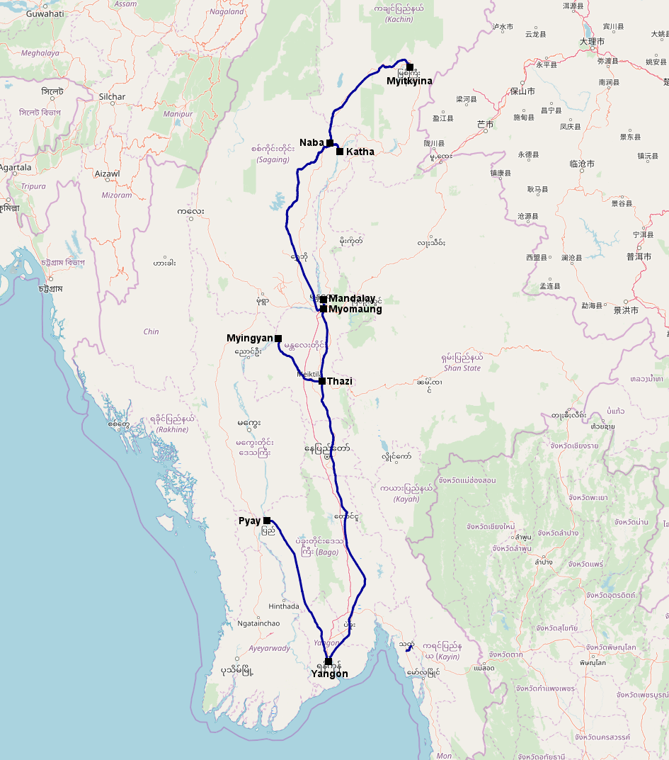 Figure 1: The Burmese railway network in 1899
The opening of the Suez Canal increased the demand for Burmese products. The network was very busy especially during the rice paddy season. The “Burma Railways Company” invested heavily in additional rolling stock and built branch lines to bring additional traffic on the main lines. In addition strategic reasons required the construction of the first mountain line in Burma. The French had started to build a railway from their colony Indochina into the Chinese Yunnan province. In order to confine French influence the British started to build a railway line from Mandalay towards the Chinese borders. Several reversals as well as the construction of the Gokteik Viaduct, one of the largest railway viaducts at its construction, were required to build a line through the mountainous Shan highlands. The line reached Lashio in 1903, however a further prolongation towards the Chinese border was never realized.
In order to facilitate transportation of rice, a railway line was built in the Irrawaddy Delta west of the Irrawaddy River between Bassein (Pathein) and Kyangin between 1901 and 1907. It was connected with the rest of the railway network using a ferry between Hinthada and Tharraw across the Irrawaddy River. The southern part of Myanmar was also connected to the railway network by building a line from Pegu (Bago) to Mottama on the shore of the Salween (Thanlwin) River which was opened in 1907. Further branch lines opened until the First World War included Ywataung - Alon (opened 1900), another mountain line from Thazi to Aungban (opened between 1912 and 1915) and a branch line from Mahlwagon to Bauktaw in the Greater Rangoon area (opened 1911). In addition parts of the line between Rangoon (Yangon) and Mandalay received a second track.
On the eve of World War One, the Burma State Railways operated more than 1.500 miles (2.500 km) of tracks with around 400 sidings, more than 300 steam locomotives were in service.
| Line | From | To | Length (km) | Length (miles) | Opening date |
| E10 (Myohaung – Lashio) | Myohaung | Pyin Oo Lwin (Maymyo) | 64.0 | 39.8 | 01.04.1900 |
| Pyin Oo Lwin (Maymyo) | Nawngkhio | 53.9 | 33.5 | 22.04.1900 | |
| N11 (Ywataung – Khin-U) | Ywataung | Alon | 113.5 | 70.5 | ??.04.1900 |
| E10 (Myohaung – Lashio) | Nawngkhio | Hsipaw | 86.1 | 53.5 | 01.07.1901 |
| W13 (Hinthada – Hinthada Shore) | Hinthada | Hinthada Shore | 4.4 | 2.8 | ??.??.1901 |
| C11 (Letpadan – Tharrawaw) | Letpadan | Tharrawaw | 37.8 | 23.5 | ??.??.1903 |
| E10 (Myohaung – Lashio) | Hsipaw | Lashio | 82.5 | 51.3 | 01.03.1903 |
| W10 (Pathein – Pakokku) | Pathein | Hinthada | 132.4 | 82.3 | ??.04.1903 |
| S10 (Bago – Mottama) | Bago | Abaya | 38.6 | 24.0 | ??.??.1907 |
| S12 (Abaya – Mokepalin) | Abaya | Mokepalin | 16.1 | 10.0 | ??.??.1907 |
| S10 (Bago – Mottama) | Mokepalin | Mottama (old station) | 142.0 | 88.2 | ??.??.1907 |
| W10 (Pathein – Pakokku) | Hinthada | Kyangin | 104.2 | 64.8 | ??.??.1907 |
| Y01 (Yangon – Danyingon) | Ma Hlwa Gone | Bauktaw | 3.2 | 2.0 | ??.??.1911 |
| E20 (Thazi – Shwenyaung) | Thazi | Payangazu | 21.3 | 13.3 | ??.??.1912 |
| Payangazu | Yinmabin | 15.7 | 9.8 | ??.08.1914 | |
| Yinmabin | Kalaw | 64.4 | 40.0 | 15.12.1914 | |
| 980.1 | 609.3 |
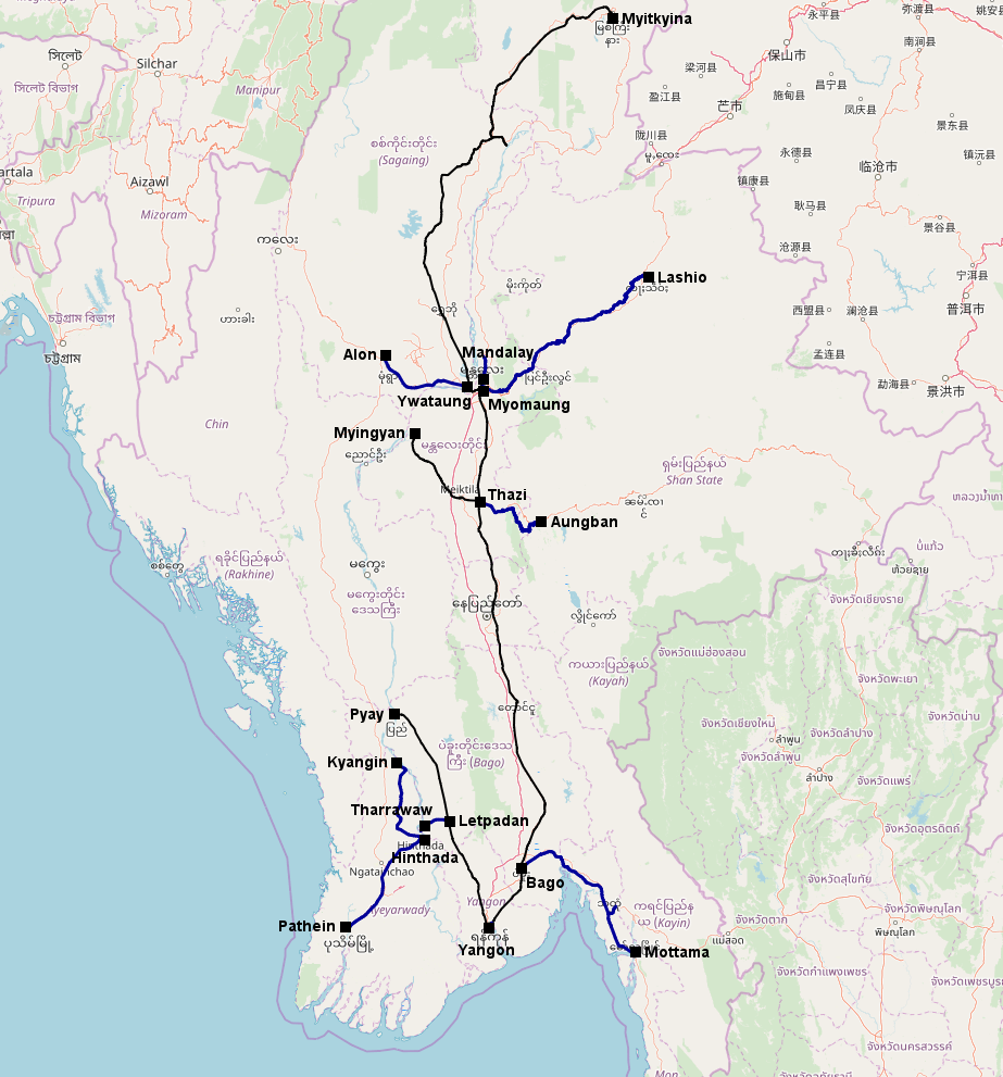 Figure 2: The Burmese State Railway network in 1915. Marked in bold and blue are the lines opened between 1900 and 1915, lines already existing in 1900 are marked in black.
Transportation figures for goods were on the up and up during the first years of the 20th century, but after the First World War the demand for Burmese products on the world market slumped. Throughout the First World War, 32 locomotives were requisitioned and transported to East Africa, Mesopotamia and India, only five returned after the war. The “Burma Railway Company” had to cope with various problems: one the one hand revenues decreased due to lower transportation figures, on the other hand the over-aged and reduced rolling stock required substantial investments while growing individual traffic with lorries and cars on newly built roads exposed the railway to a new competition. Growing deficits finally resulted in a takeover of the “Burma Railway Company” by the colonial administration where the now renamed “Burma Railways” soon became the largest cause of deficit in the financial figures.
The heavy investments into new locomotives of Indian State Railways standard types as well as Mallets and Garratts only left few financial resources left for a further expansion of the railway network. Existing branch lines were prolonged and further branch lines opened in order to bring more traffic to the main lines and to use the full capacities of the existing rolling stock. The prolongations included extensions from Kalaw to Shwenyaung (opened 1915/21), Moulmein (Mawlamyaing) to Ye (opened 1925), Bauktaw to Mingaladon Cantonment (opened 1926) and Alon to Ye-U (opened 1926). New branch lines were Pegu (Bago) to Thongwa (opened 1928), Nyaunglebin to Madauk (opened 1929), Pyinmana – Kyaukpadang (opened 1930) and Paleik – Myotha (opened 1930). In addition the State Railways took over and re-gauged the bankrupt Madaya Light Railway from Mandalay to Madaya in 1923/27 and built the first railway bridge over the Irrwaddy River between Amarapura and Sagaing in 1934.
After 1934 the construction of new lines as well as the purchase of new locomotives came to a standstill. Nothing changed at Burma Railways when Burma was separated from India and became a separate colony. On the eve of World War Two the Burma Railways operated nearly 2,000 miles of track (more than 3,000km) with around 350 steam locomotives.
| Line | From | To | Length (km) | Length (miles) | Opening date |
| E20 (Thazi – Shwenyaung) | Kalaw | Aungban | 11.3 | 7.0 | 15.02.1915 |
| Aungban | Heho | 27.0 | 16.8 | ??.03.1921 | |
| Heho | Shwenyaung | 18.1 | 11.3 | 02.05.1921 | |
| N11 (Ywataung – Khin-U) | Alon | Budalin | 24.2 | 15.0 | ??.??.1922 |
| S11 (Da Wei Inn – Thongwa) | Da Wei Inn | Khayann | 58.6 | 36.4 | ??.??.1922 |
| S30 (Mawlamyaing South – Myeik) | Mawlamyaing South | Thanbyuzayat | 56.7 | 35.3 | ??.04.1924 |
| C24 (Pyinmana – Myingyan) | Pyinmana | Satthwa | 92.9 | 57.8 | ??.04.1925 |
| S30 (Mawlamyaing South – Myeik) | Thanbyuzayat | Ye | 86.8 | 53.9 | ??.04.1925 |
| C24 (Pyinmana – Myingyan) | Satthwa | Taungdwingyi | 14.9 | 9.3 | ??.12.1926 |
| N11 (Ywataung – Khin-U) | Budalin | Ye-U | 56.3 | 35.0 | ??.??.1926 |
| Y01 (Yangon – Danyingon) | Bauktaw | Mingaladon Cantonment | 11.3 | 7.0 | ??.??.1926 |
| S11 (Da Wei Inn – Thongwa) | Khayann | Thongwa | 14.4 | 8.9 | ??.??.1928 |
| C22 (Nyaunglebin – Madauk) | Nyaunglebin | Madauk | 18.1 | 11.3 | ??.08.1929 |
| C24 (Pyinmana – Myingyan) | Taungdwingyi | Kyaukpadang | 115.6 | 71.8 | ??.??.1930 |
| C28 (Paleik – Myingyan) | Paleik | Myotha | 43.1 | 26.7 | ??.??.1930 |
| N10 (Myohaung – Myitkyina) | Amarapura | Ywataung | 5.2 | 3.3 | ??.??.1934 |
| 671.7 | 417.5 |
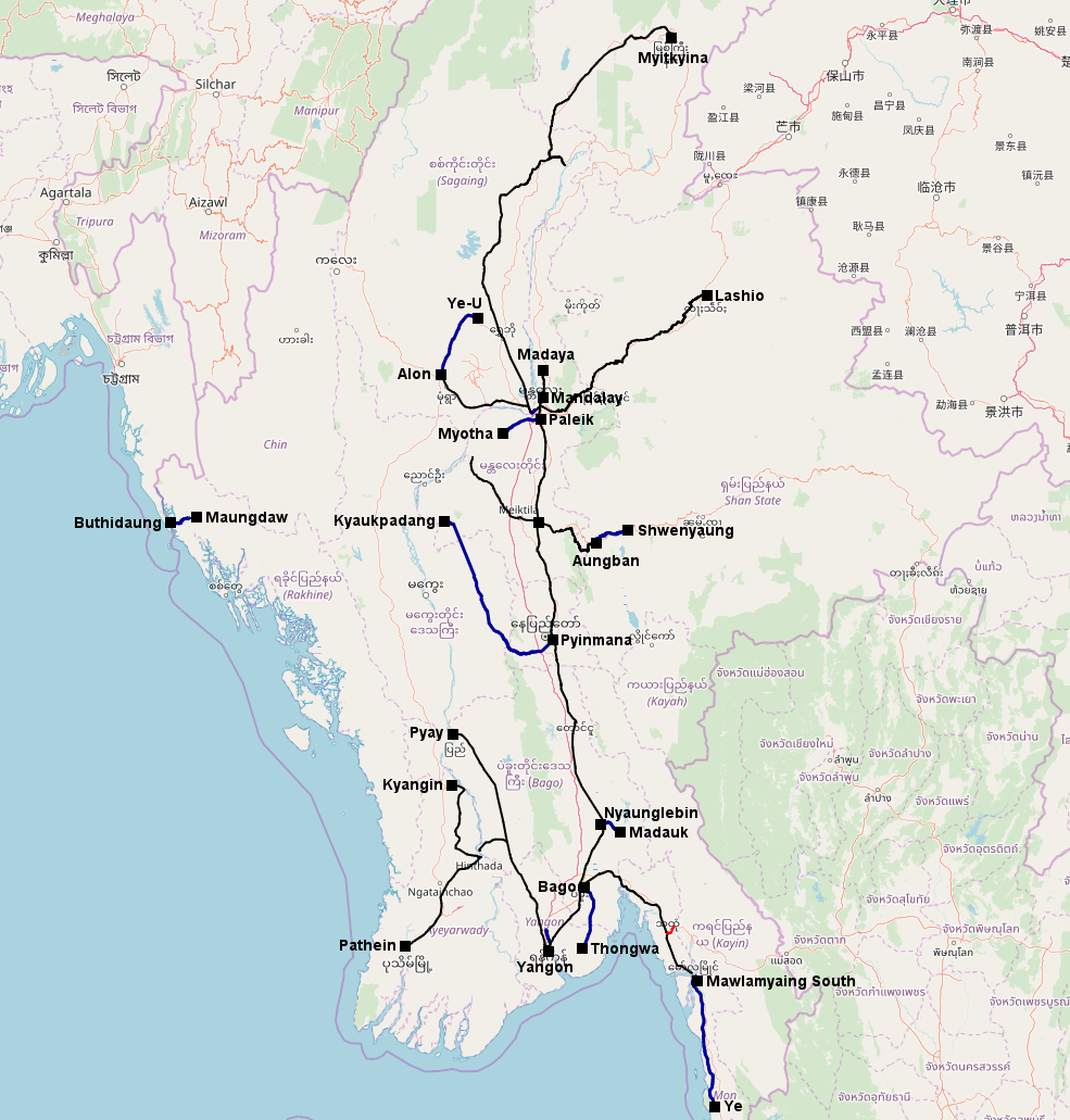 Figure 3: The Burmese State Railway network in 1939. Marked in bold and blue are the lines opened between 1916 and 1939, lines already existing in 1916 are marked in black. Lines which were closed and/or dismantled during that time are marked in bold red.
In order to support Chinese National troops which had retreated to the Southern province of Yunnan against the Japanese troops, plans to prolong the line from Lashio into China as initially planned were revived. But works were stopped just after they had started as things changed much faster than expected. In late December 1941 World War Two arrived in Burma when the first Japanese troops attacked Southern Burma. Surprised by the attack the British troops couldn’t show much resistance. Rolling stock was evacuated to the Northern parts of Burma as far as possible while all that was left back was destroyed by British troops. Rangoon (Yangon) fell in March 1942 and at the start of the raining season 1942 most British troops had evacuated to Bengal and Assam in India.
The Japanese focussed on the strategic importance of the railways by building a railway link between Burma and Thailand. The 415km long (of which only 111km were running through Burma) line from Ban Pong in Thailand to Thanbyuzayat on the Burmese line from Moulmein (Mawlamyaing) to Ye was opened in December 1943. Several tens of thousands of prisoners of war and forced labourers died during the construction of the “death railway” which became famous by the book and movie “The Bridge on the River Kwai”. Required materials for the construction of the death railway as well as for the rehabilitation of important lines destroyed by British troops were obtained by dismantling the lines Thanbyuzayat – Ye, Taungdwingyi – Kyaukpadang, Tadau-U – Myotha, Alon – Ye-U as well as the second track between Rangoon (Yangon) and Mandalay.
The Japanese troops brought at least 35 used Japanese cape gauge locomotives to Burma where they were used after having been re-gauged to metre gauge. Further locomotives from Thailand, Malaysia, Singapore and maybe even Indonesia found their way to Burma after the opening of the death railway”.
In late 1944 British and US troops started attacks from North-Eastern India on Northern and Western Burma. They took Myitkyina and quickly advanced further south along the railway line. The troops brought small petroleum locomotives as well as old steam locomotives from Assam & Bengal Railways to Burma, later 57 of the bigger MacArthur class steam locomotives followed. By the end of July 1945 the Allied troops had gained full control of Burma leaving behind a devastated railway. Most of the bridges were destroyed and the once more than 3,000km long railway network was split into four isolated parts of which overall only 1,085km were operational. Out of the around 350 locomotives available before the war, only around 150 were left in working order after the war (including the nearly 100 locomotives brought into the country by Japanese and Allied troops).
| Line | From | To | Length (km) | Length (miles) | Opening date |
| S31 (Thanbyuzayat – Payathouzu) | Thanbyuzayat | Payathouzu | 111.4 | 69.3 | 25.10.1943 |
| 111.4 | 69.3 |
| Line | From | To | Length (km) | Length (miles) | Closing date |
| S30 (Mawlamyaing South – Myeik ) | Thanbyuzayat | Ye | 35.4 | 22.0 | 1942? |
| C24 (Pyinmana – Myingyan) | Taungdwingyi | Kyaukpadang | 115.6 | 71.8 | 1942? |
| C28 (Paleik – Myingyan) | Tada-U | Myotha | 15.7 | 9.8 | 1942? |
| N11 (Ywataung – Khin-U) | Alon | Ye-U | 80.5 | 50.0 | 1942? |
| 247.2 | 153.6 |
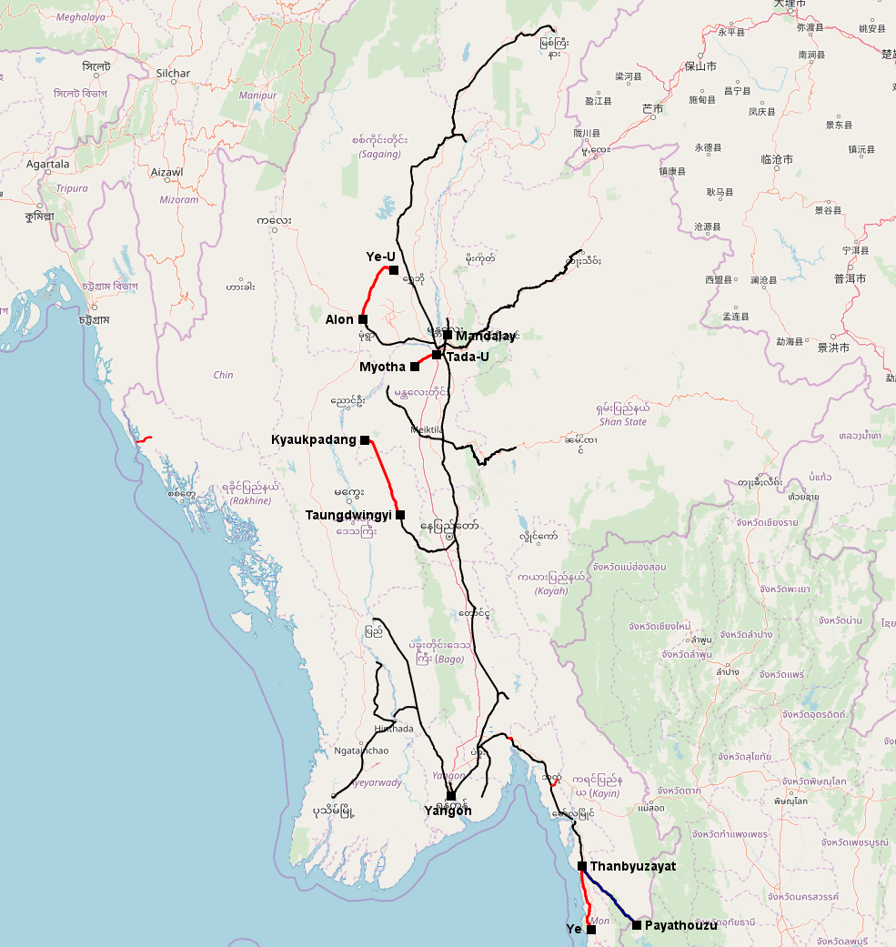 Figure 4: The Burmese State Railway network in 1945. Marked in bold and blue are the lines opened between 1940 and 1945, lines already existing in 1940 are marked in black. Lines which were closed and/or dismantled during that time are marked in bold red.
As a quick relief 31 war department Garratts which originally operated on the Assam & Bengal Railways to supply Allied troops were brought to Burma in 1946. Further locomotives were exchanged with Thailand, Malaysia and Singapore until the “death railway” was dismantled on the Burmese side in 1947 for rehabilitation of other lines in Burma. Between 1947 and 1950 more than 100 new steam locomotives of Indian standard classes were ordered in Britain.
The quick independence of Burma in 1948 made the rehabilitation of the railway not easier. Rising economic problems and insurgencies let to further delays. In 1962 3,020km of tracks were serviceable nearly reaching pre-war figures. The first eight diesel locomotives were ordered in 1958 followed by another 81 in the 1960s. Nevertheless large parts of the trains were still pulled by steam locomotives; steam operations finally ceased in April 2008.
The isolation of the country pushed by the military junta since 1962 more or less kept the status quo of the railways. The passenger and goods transport still largely relied on the railways. Further diesel locomotives were ordered in the 1970s and 1980s. The railway network hardly saw any changes. Alongside the “death railway” the line between Bago and Thongwa was dismantled in 1957 and the line from Mandalay to Madaya was interrupted in 1978 when the moats of the King Palace were reconstructed. New railway lines were built between Mingaladon Cantonment and Danyingon (opened 1959 as the last remaining part of the Rangoon Circle Line), Abaya and Mokepalin (opened 1962 as part of a new bridge over the Sittang River some kilometres north of the bridge destroyed in WW II) and Kyaukpadang to Kyeeni (opened in 1969 to connect the oil fields near Magway to the railway network). In addition the section Taungdwingyi – Kyaukpadang dismantled by the Japanese in 1943 was reopened in 1969. Finally the cement works at Myaingalay were connected to the railway network.
| Line | From | To | Length (km) | Length (miles) | Opening date |
| Y01 (Ma Hlwa Gone – Danyingon) | Mingaladon Cantonment | Danyingon | 6.0 | 3.7 | 01.05.1959 |
| S10 (Bago – Mottama) | Abaya | Mokepalin | 22.7 | 14.1 | 23.03.1962 |
| C92 (Kyaukpadang – Chauk) | Kyaukpadang | Kyeeni | 39.3 | 24.4 | 01.03.1969 |
| S14 (Thaton – Myaingalay) | Thaton | Duyinzeik | 13.6 | 8.5 | 31.12.1984 |
| Duyinzeik | Myaingalay | 22.9 | 14.2 | 27.03.1988 | |
| 104.5 | 64.9 |
| Line | From | To | Length (km) | Length (miles) | Reopening date |
| C24 (Pyinmana – Myingyan) | Taungdwingyi | Kyaukpadang | 115.6 | 71.8 | ??.??.1969 |
| 115.6 | 71.8 |
| Line | From | To | Length (km) | Length (miles) | Closing date |
| S31 (Thanbyuzayat – Payathouzu) | Thanbyuzayat | Payathouzu | 108.9 | 67.6 | ??.??.1947 |
| S11 (Da Wei Inn – Thongwa) | Bago | Thongwa | 73.0 | 45.4 | ??.??.1957 |
| C29 (Mandalay – Madaya ) | Mandalay | Mandalay Madaya Station | 3.2 | 2.0 | ??.??.1978 |
| 185.1 | 115.0 |
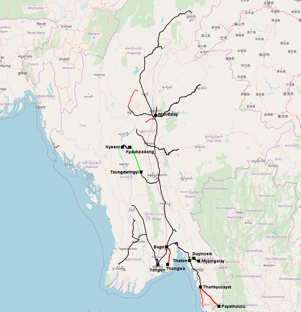 Figure 5: The Burmese State Railway network in 1988. Marked in bold and blue are the lines opened between 1945 and 1988, lines already existing in 1940 are marked in black. Lines which were closed and/or dismantled during that time are marked in bold red, lines closed before that period are marked in thin red lines, rebuilt lines are marked in bold green.
After the protests and uprisings in 1988 a new generation of generals came to power. They changed the name of the country to Myanmar and the “Burma Railways” were renamed to “Myanma Railways”. The new generals put a high emphasis on the railway as it should revive the economy, cater for tourist business and connect remote areas to the rest of the countries. Strategic reasons also played a vital role as the junta wanted to have alternative routes between Yangon and the northern parts of the country. Thus ambitious plans were made to build new railway lines and to connect each State and Division of the country to the railway network.
The construction of new railway lines was supervised by the army which had hardly any knowledge of railway construction. Construction started in the remote areas and often isolated lines not connected to the rest of the railway network were opened. Required materials and disassembled rolling stock was brought to the isolated lines with the help of old military trucks or sometimes even elephants. Manual labour often by forced labour or prisoners was used instead of machines. The construction of bridges and tunnels was avoided wherever possible, the first alignment of tracks often had sharp curves and radii which were not manageable by locomotives. When opened only railcars with a maximum speed of a few km/h could travel on the lines. During the rainy season the lines were often completely destroyed. Nevertheless until 2011 the length of the railway network had nearly doubled since 1988 to more than 6,000km.
The aging fleet of steam and diesel locomotives as well as the expansion of the railway network required additional rolling stock. New and used diesel locomotives were purchased from China and India. Local trains and remote lines were operated with self-constructed railcars based on lorry bodies. In 2004 Myanma Railways had started to purchase used kiha railcars from Japan which are used for all kinds of passenger services after having been re-gauged from cape gauge to metre gauge. Steam locomotives were in service until April 2008!
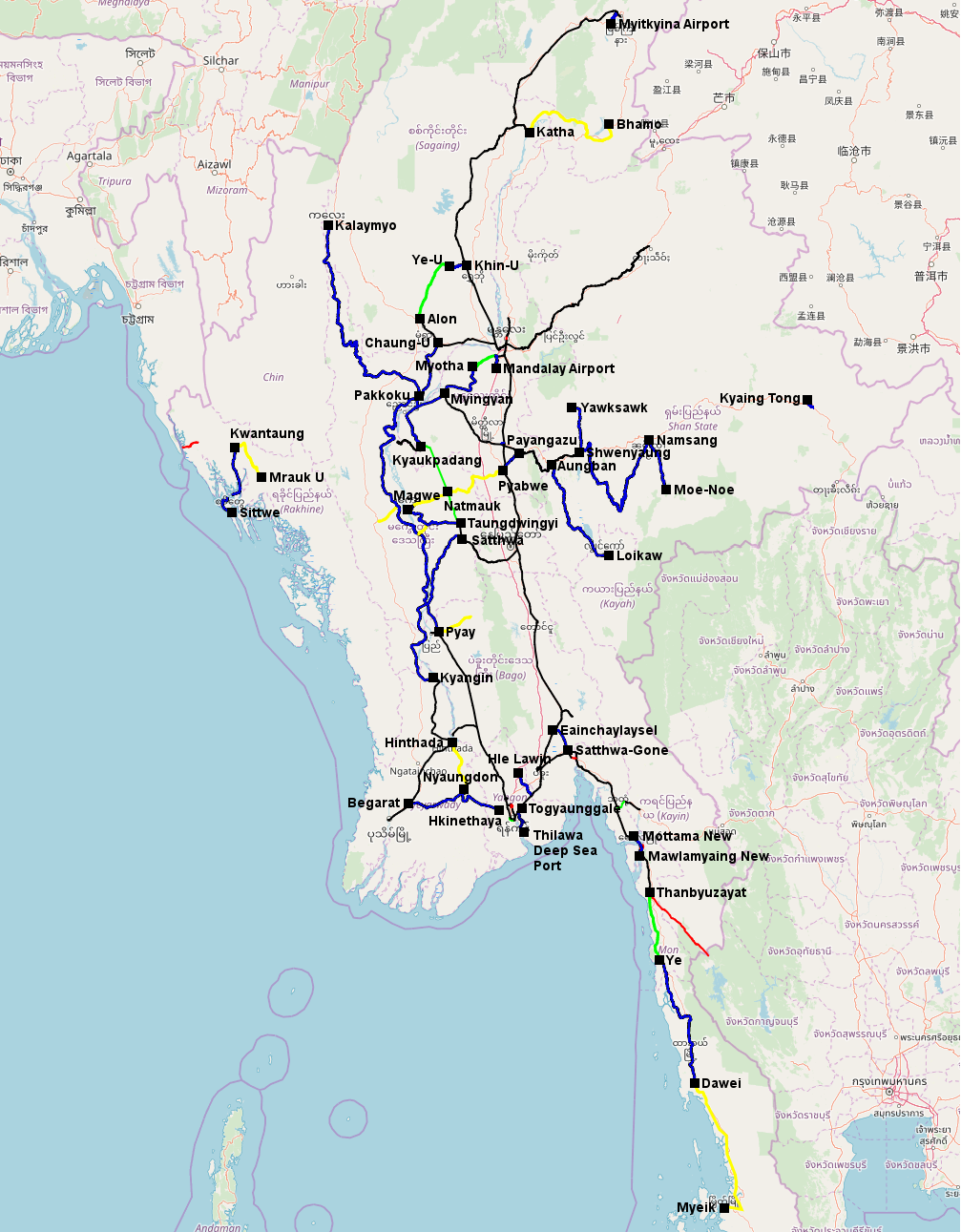 Figure 6: The Burmese State Railway network in 2011. Marked in bold and blue are the lines opened between 1988 and 2011, lines already existing in 1988 are marked in black. Lines which were closed and/or dismantled during that time are marked in bold red, lines closed before that period are marked in thin red lines; rebuilt lines during that period are marked in bold green, lines rebuilt before that period are marked in thin green. Lines under construction are marked in yellow.
The political changes and the opening up of the country since 2011 had a massive impact on the railways. The import of cars, trucks and busses had been heavily restricted by the military junta in the past. In 2009 a 30 year old Toyota Corolla cost about 30,000US$ while the average annual salary of a teacher was around 10US$! But since the lifting of restriction a massive influx of cars, busses and lorries happened and the run down railways have no chance to compete. Transportation figures of passengers and goods dropped heavily. Work on lines under construction was completely stopped and new lines planned under the military junta will most probably never be realized. Train services on most of the finished new lines was completely suspended, some of these lines were most probably only a few months in operation. The train services on the old lines were massively reduced or completely suspended (especially on the short branch lines like Nyaunglebin – Madauk). The military junta had granted the Chinese the right to build a naval base and an oil port on Ramree Island. While the oil port was connected with a pipeline to the Chinese province Yunnan, a normal gauge railway planned by the Chinese between Ramree Island and Yunnan province will most probably never be built as the relationship between Myanmar and China has deteriorated after the step down of the military junta.
The “Myanma Railways” are now focussed on public transport in Yangon and on long distance trains between Yangon and Mandalay and Mandalay and Myitkyina. With the help of Japanese development funds the Circle line in Yangon should be electrified and the main line between Yangon and Mandalay should be modernized by installing new signal equipment and improve track quality in order to allow maximum speed of 100km/h (currently he maximum speed is less than 50km/h on most main line sections). The aging fleet of diesel locomotives is more and more replaced with used kiha diesel railcars from Japan, the self-built railcars have completely disappeared just a few years after they went into service.
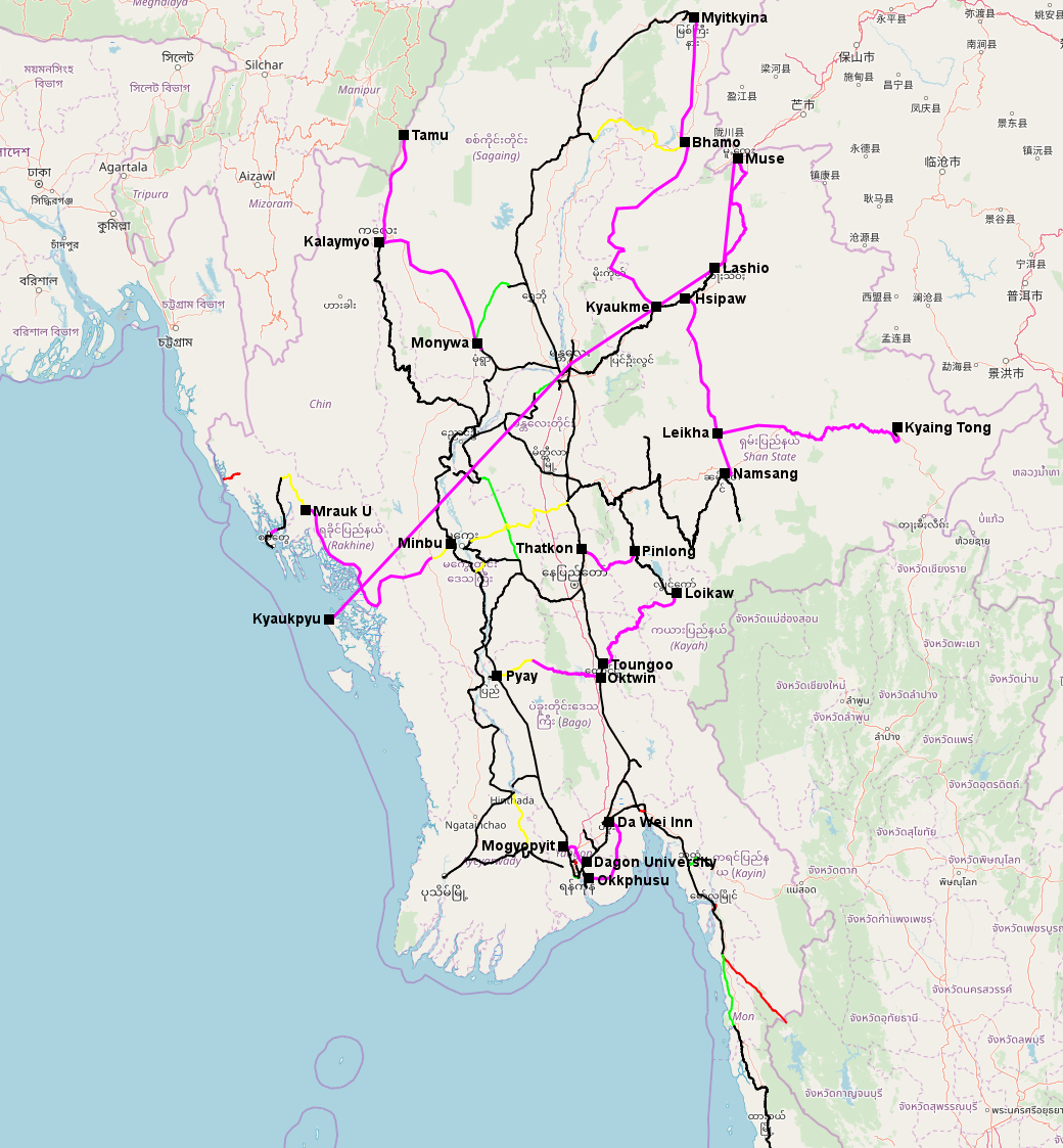 Figure 7: The current state of the railway network in Myanmar. Lines marked in pink are planned lines by the military junta which will most probably never be built. Lines under construction or where construction works have been halted are marked in yellow. Rebuilt lines are marked s green.