Main Lines (Ring Line)
The main lines of the governmental railways TRA consist more or less of the different sections of the ring line around the island. There are just two short sections branching of the ring line (Badu – Keelung, Su’aoxin –Su’ao) as well as a parallel section between Zhunan and Changhua. The different sections of the ring line result out of the historic development of the ring line.
 Figure 1: This map shows the different sections of the ring line: Western/ Trunk Line (blue), Mountain/ Taichung Line (pink), Pingtung Line (orange), Yilan Line (red), North Link Line (turquoise), South Link Line (green). Branch line in service by TRA are marked in grey (Terrain by Stamen.com)
The different sections are described in more detail below. Please click on the headings to expand the areas.
Western/Trunk Line
The Western Line runs from the harbour of Keelung on the northern tip of the island via Taipei to the second largest city Kaohsiung in the southwestern part of the island. It is the backbone of the governmental railway system on Taiwan and is thus often called Trunk Line. The line connects the fertile plains on the western coastline of the island where around 90% of the total population lives. In 2016, around 170 million passengers were transported on the cape gauge line, which is completely electrified and double-tracked except some short sections between Zhunan and Changhua.
It took nearly 20 years to construct the total line. The 28.3km long first section between Taipei (Twatutia Station) and Keelung was opened in October 1891. It was the first permanent public railway in China (other non-public railways opened earlier, e.g. a coal mine railway near Keelung already started operations in 1877; a public railway constructed by the British in Shanghai in 1876 had to be removed after a few months). The line was prolonged for 78.1km to Hsinchu two years later. A planned prolongation to Kaohsiung failed due to missing funds. After the Japanese occupation in 1895, the railway line became of high strategic importance and the rather poor layout of the line with tight curves and sharp inclines forced the Japanese Army to a realignment of the tracks in between Taipei and Keelung. The Japanese occupation was initially met with resistance and insurgencies. Thus, the Japanese Army asked for a quick prolongation of the line to Kaohsiung. However, funds were also scarce in the Japanese Government and the Army constructed the prolongation itself using a Decauville system with 500mm gauge and human power. Several private initiatives to build the prolongation failed. Thus, the government finally decided to build the line by issuing additional bonds. Construction started from both sides. In the southern part, the 46.6km long section between Kaohsiung and Tainan was opened on the 29th November 1900, the 142.3km long section from Tainan to Changhua followed on the 26th March 1905. Progress in the northern part was much slower, the section between Hsinchu and Zhunan opened in 1903. The missing link between Zhunan and Changhua was subject to long discussions regarding the alignment. Two alternatives were proposed:
- An alignment along the coast line, which had less geographic obstacles but did not touch the city of Taichung, one of the largest cities on Taiwan at that point of time (Coast Line).
- An alignment further inland, which touched the city of Taichung but also required the crossing of a mountain range with sharp inclines, long bridges and tunnels (Mountain Line).
 Figure 2: This map shows the Western/Trunk Line in blue with its opening dates (Terrain by Stamen.com)
Within the area of Kaohsiung, the alignment of the Western/Trunk Line changed throughout the year. The first station was close to the harbour. In 1908, land reclamations required the relocation of the terminus station around 500m further south. Kaohsiung soon became the most important industrial centre of Taiwan and quickly grew towards the north and east. Thus, the Japanese government decided to relocate the main station to the northern suburbs. The new station was opened in 1941 and since then, most passenger trains on the Western/Trunk Line started or ended at the new station whereas trains on the Pingtung Line still started or ended at the old harbour station. The section between Gushan and the harbour station became a branch and finally closed in 2008. Parts of the track bed should be reused for the construction of the ring line tram (see Metro Systems).
 Figure 3: This map shows the Western/Trunk Line in blue within the Kaohsiung city area. Lines marked in grey were closed latest in 2008 (Terrain by Stamen.com)
| From | To | Length (km) | Opening Year | Remark |
| Keelung (基隆) | Taipei (台北) | 28.3 | 1891 | opened November 1891; realignment 1895 - 1897 |
| Taipei (台北) | Taoyuan (桃園) | 29.1 | 1891 | opened November 1891 |
| Taoyuan (桃園) | Zhongli (中壢) | 9.9 | 1892 | opened July 1892 |
| Zhongli (中壢) | Hsinchu (新竹) | 39.1 | 1893 | opened June 1893 |
| Hsinchu (新竹) | Zhunan (竹南) | 19.0 | 1903 | |
| Zhunan (竹南) | Qingshui (清水) | 65.3 | 1922 | opened 11.10.1922 |
| Qingshui (清水) | Changhua (彰化) | 24.9 | 1920 | opened 25.12.1920 |
| Changhua(彰化) | Tainan (臺南) | 142.3 | 1905 | opened 26.03.1905 |
| Tainan (臺南) | Gushan (鼓山) | 44.1 | 1900 | opened 29.11.1900 |
| Gushan (鼓山) | Kaohsiung (高雄) new station | 2.5 | 1941 | Relocation of Kaohsiung Main Station |
| Gushan (鼓山) | Kaohsiung (高雄) First Station | 2.1 | 1900 | opened 29.11.1900; closed 2008, track bed planned for Kaohsiung tramway |
| Kaohsiung (高雄) First station | Kaohsiung (高雄) Harbour | 0.5 | 1908 | closed 2008, track bed planned for Kaohsiung tramway |
| 404.5 | excluding closed section to Kaohsiung port (2.6km) |
Double-tracking of the Western/Trunk Line already started in 1912 and was finished in the section from Keelung to Taipei in 1919. The sections between Taipei and Zhunan as well as between Tainan and Kaohsiung were double-tracked in the 1930s. To meet the growing transportation demands, the line was electrified in 1979 with overhead wire (25kV 60Hz) and most of the remaining parts were double-tracked. The many railway crossings are a frequent source for accidents as well as the cause for severe traffic jams in the cities. Thus, the complete Western/Trunk Line was put underground in the area of Taipei between 1979 and 2004. Taoyuan and recently Kaohsiung followed. With the opening of the high-speed line between Taipei and Kaohsiung in 2007, the Western/Trunk Line lost most of its express trains and its importance in long distance travel. On the other hand, commuter traffic on the line has massively increased during the last two decades within the agglomerations of Keelung, Taipei, Taoyuan, Taichung and Kaohsiung. Even though the three biggest ports of Taiwan (Keelung, Taichung, Kaohsiung) are/were directly connected to the Western/Trunk Line, there is hardly any goods traffic left on the line.
 Figure 4: A commuter train to Keelung enters Hsinchu North Station. While commuter traffic on the Western/Trunk Line heavily increased during the last two decades, hardly any express and goods trains still run on the line (Photo by billy1125 from Taiwan / CC BY (https://creativecommons.org/licenses/by/2.0) in Wikimedia Commons)
 Figure 5: An express train (left) and a commuter train meet at Hsinchu station, one of the most important stations between Taipei and Kaohsiung (Photo by Lexcie / CC BY-SA (https://creativecommons.org/licenses/by-sa/3.0) in Wikimedia Commons).
The Mountain/Taichung Line was initially part of the Western/Trunk Line (see above). Construction of the Western/Trunk Line started from both ends. There were long discussions on which alignment the track should take between Zhunan and Changhua as a mountain range comes close to the western coastline in this area. Easier to construct would have been a line alongside the coast as there was no need to cross the more than 400m high mountain range. Nevertheless, an alignment that crosses the mountain range between Sanyi and Houli was chosen in order to connect the city of Taichung to the railway network. Crossing of the mountain range required the construction of long tunnels and bridges, the largest being the Longteng Bridge with more than 200m length and 50m height. Thus, the 87.9km long line was only opened on 20th February 1908 as the last missing link of the Western/Trunk Line. The mountain section soon became a severe bottleneck of the complete railway network as all trains required push support by additional locomotives, which limited the capacity of the line. Finally, the alternative alignment along the coastline was realized in 1922 and since then most trains used this section. The mountain section, which was initially part of the Western/Trunk Line, remained in service and became the Mountain/Taichung Line.
 Figure 6: Historical view dating from 1910 of the Longteng Bridge, the largest bridge on the mountain section between Sanyi and Houli (author unknown / Public domain in Wikimedia Commons).
The Longteng Bridge was destroyed during an earthquake in 1935. It was reopened in 1938 in a much simpler form. While most goods trains used the coastal section, passenger trains still used the Mountain/Taichung Line as they passed by Taichung, one of the largest cities on the island. During the 1950s, two branch lines were opened within the area of Taichung (see Shenggang and Dongshi Line at Branch Lines). In order to compete with the growing flight and road traffic, the TRA tried to accelerate passenger trains on the line by building a long tunnel between Sanyi and Houli to cross the mountain range. The new alignment, which included double-tracking and electrification of the complete Mountain/Taichung Line, was opened in 1998. It shortened the total length of the line by 2.4km and since then most trains are re-routed from the coastal section of the Western/Trunk Line to the Mountain/Taichung Line. Thus, the Mountain/Taichung Line regained the importance that it once lost after the opening of the coastal section of the Western/Trunk Line in 1922. The old mountain section between Sanyi and Houli was closed for several years. A few years ago, irregular heritage trains (some even steam-hauled) were introduced on the old mountain section between Sanyi and Tai’an, the following section to Houli remains unused as it basically consists of a tunnel followed by a long bridge. In 2016 as part of the realignment program of the TRA within the agglomerations, the line was put on bridges within the city of Taichung and received additional stations for enhanced commuter traffic. Construction of a link between the Mountain/Taichung Line and the Western/Trunk Line north of Taichung, which would form a ring line around the agglomeration of Taichung is planned (see Planned Lines for details).
 Figure 7: A heritage train pulled by CK 124 passes the new Longteng Bridge on the mountain section. The foreground shows the remains of the old Longteng Bridge, which was destroyed in an earthquake 1935.
 Figure 8: This map shows the Mountain/Taichung Line in pink. The old mountain section between Sanyi and Houli is marked in light pink. The Western/Trunk Line is marked in blue. Lines branching of the Mountain/Taichung Line are marked in grey (Terrain by Stamen.com)
 Figure 9: Detailed map of the mountain section between Sanyi and Houli with old alignment (light pink) and the new alignment opened in 1998 (Terrain by Stamen.com)
| From | To | Length (km) | Opening Year | Remark |
| Zhunan (竹南) | Miaoli (苗栗) | 15.2 | 1903 | |
| Miaoli (苗栗) | Sanyi (三義) | 18.2 | 1904 | |
| Sanyi (三義) | Changhua(彰化) | 54.5 | 1908 | opened 20.02.1908 |
| Sanyi (三義) | Houli (后里) | 13.5 | 1998 | realignment & long tunnel to avoid old mountain section; opened 24.09.1998 |
| Sanyi (三義) | Houli (后里) | 15.9 | 1998 | closure of old mountain section due to new alignment & tunnel; irregular heritage trains between Sanyi and Tai’an |
| 87.9 | realignment 1998 shortened the line by 2.4km |
The short Chengzhui Line forms a track triangle north of Changhua together with the Mountain/Taichung Line and the coastal section of the Western/Trunk Line. The 2.2km long section between Chenggong and Zhuifen was opened on the 11th October 1922 alongside the remaining part of the coastal section of the Western/Trunk Line and allows direct trains from Taichung to the coastal area. For a long time, the line had just minor importance. However, with the growing commuter traffic around Taichung, the line was double-tracked and electrified in 2020.
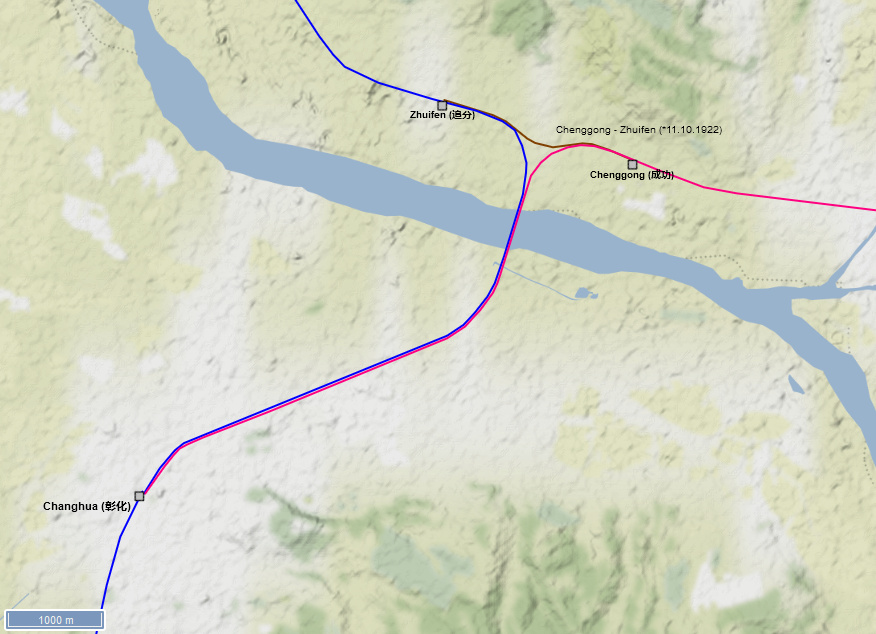 Figure 10: The Chengzhui Line marked in brown forms a track triangle north of Changhua together with the Mountain/Taichung Line marked in pink and the coastal section of the Western/Trunk Line marked in blue (Terrain by Stamen.com)
| From | To | Length (km) | Opening Year | Remark |
| Chenggong (成功) | Zhuifen (追分) | 2.2 | 1922 | 11.10.1922 |
| 2.2 | realignment 1998 shortened the line by 2.4km |
 Figure 11: The railcars EMU555 and EMU556 on the Chengzhui Line. To the left the Mountain/Taichung Line branches off toewards Changhua (Cheng-en Cheng, CC BY-SA 2.0
The extension of the Western/Trunk Line towards the southern tip of the Island was opened in several steps. Starting point of the Pingtung Line was the first station of the Western/Trunk Line near the port of Kaohsiung. The first section with a length of 16.9km to Jiuqutang went into operations in 1907. To reach the city of Pingtung, a large bridge crossing the Gaoping River had to be constructed. Thus, the extension to Pingtung was only opened in 1914. The terrain south of Pingtung is flat and construction of a railway line is rather easy. Nevertheless, the next extension to Xizhou/Nanzhou saw its first traffic only in 1923. Due to World War II, the Army required the extension of the Pingtung Line to the harbour at Linbian and the coastal city of Fangliao in 1941. However, the section between Linbian and Fangliao was already dismantled in 1944, as the Japanese Army feared the landing of Allied troops. It was reopened after the war in 1953. Fangliao remained a terminus until 1991 when the South Link Line connected Fangliao with Taitung on the east coast. The large iron bridge over the Gaoping River was replaced with a new concrete bridge in 1987. Double-tracking of the line between Kaohsiung and Pingtung started in 1989. By now, most sections of the Pingtung Line are double tracked. Electrification of the line was finished in 2019. As part of the modernization of the line, the section within Kaohsiung was put underground and within Pingtung the line runs on a bridge.
 Figure 12: This map shows the sections of the Pingtung Line in orange with their respective opening dates. The Western/Trunk Line is marked in blue, the South Link Line is marked in green. Other governmental railway lines (all closed) are marked in grey (Terrain by Stamen.com)
| From | To | Length (km) | Opening Year | Remark |
| Kaohsiung (高雄) First station | Jiuqutang (九曲堂) | 16.9 | 1907 | section Kaohsiung First Station - Kaohsiung closed in 2008 (-3.1km) |
| Jiuqutang (九曲堂) | Pingtung (屏東) | 7.2 | 1914 | |
| Pingtung (屏東) | Xizhou/Nanzhou (南州) | 22.3 | 1923 | |
| Xizhou/Nanzhou (南州) | Fangliao (枋寮) | 18.0 | 1941? | 11.2km long section from Linbian (林邊) to Fangliao (枋寮) dismantled in 1944 and reopened 1953 |
| 64.4 | including 3.1km long section from Kaohsiung First Station to Kaohsiung |
.jpg) Figure 13: A diesel rail car on the southern section of the Pingtung Line in November 2015 before the electrification and double-tracking took place (billy1125 from Hualien, Taiwan, CC BY 2.0
Figure 13: A diesel rail car on the southern section of the Pingtung Line in November 2015 before the electrification and double-tracking took place (billy1125 from Hualien, Taiwan, CC BY 2.0  Figure 14: This is how the northern section of the Pingtung Line looks after electrification and double tracking between Kaohsiung and Pingtung (Tze Chiang Hao, CC BY-SA 4.0
In northeastern Taiwan, around the city of Yilan, there is a large alluvial plain that was used intensively for agriculture. To reach Yilan from Taipei / Keelung, a mountain range with rich coal and gold deposits had to be crossed. Despite the geographical difficulties, the Japanese decided to build the 93.6 km long Yilan Line to Su’ao at the southern end of the alluvial land to connect Yilan with the railway network and to get access to the coal and gold deposits in the mountains. The Yilan Line branches off in Badu (shortly before Keelung) on the Western Line, crosses the mountains and runs close to the coast to Su’ao. Construction began in 1917 from both directions, as the initial sections there were relatively easy to carry out at first. A new port was specially built in Su’ao so that the necessary building materials could be delivered by ship. In 1919 and 1920, the first sections were put into operation. Closing the missing gap through the difficult mountain terrain too time and only opened to traffic on December 1st, 1924.
Su’ao remained the terminus for a long time. A further extension of the Yilan Line to the south initially failed because of the rugged coastline. It was not until 1980 that the extension went into operation (see North Link Line below). However, the North Link Line does not branch off in Su'ao, but shortly before that at Su'aoxin station, so the last section of the Yilan Line between Su’aoxin and Su’ao became a branch line. Unlike the short branch lines to the city centers in Hualien or Taitung, the branch line to Su’ao is still in operation today. With the construction of the North Link Line, the Yilan Line changed from a branch line to an important thoroughfare on which the traffic increased massively. As early as 1968, the first sections were double-tracked; by 1986, the entire line had been double-tracked. Between 2000 and 2003, the Yilan Line was finally electrified. All trains going from the agglomeration of Taipei to the east coast have to take the detour via the Yilan Line. Thus, there are plans for a direct connection between Taipei and Yilan either as a cape gauge line or even as an extension of the high-speed line (see Planned Lines).
 Figure 15: Map of the Yilan Line marked in red with opening dates. The Western/Trunk Line is marked in blue, the North Link Line in turquoise. Branch Lines in service are marked in grey (Terrain by Stamen.com)
| From | To | Length (km) | Opening Year | Remark |
| Badu (八堵) | Ruifeng (瑞芳) | 8.9 | 1919 | |
| Ruifeng (瑞芳) | Houtong (猴硐) | 4.6 | 1920 | |
| Houtong (猴硐) | Dali (大里) | 26.6 | 1924 | opened 01.12.1924 |
| Dali (大里) | Jiaoxi (礁溪) | 22.8 | 1920 | |
| Jiaoxi (礁溪) | Su'ao (蘇澳) | 30.7 | 1919 | |
| 93.6 |
 Figure 16: Tunnel under construction on the Yilan Line. The mountainous area required the construction of several tunnels along the line (Unknown authorUnknown author, Public domain, via Wikimedia Commons)
 Figure 17: Workers in front of a newly constructed tunnel along the Yilan Line (Unknown authorUnknown author, Public domain, via Wikimedia Commons)
 Figure 18: The offical opening train of the Yilan Line arrives at Yilan station (Unknown authorUnknown author, Public domain, via Wikimedia Commons)
 Figure 19: Modern day traffic on the Yilan Line. A commuter train type EMU800 on the curvy northern section of the Yilan Line (jason199567, CC BY-SA 2.0
  Figure 20: A passenger train running on the coastal section of the Yilan Line (Taiwan Railways Administration, Attribution, via Wikimedia Commons)
Taiwan’s east coast is rugged with cliffs and very sparsely populated. Only between Taitung and Hualien is a somewhat wider valley that can be used for agriculture, especially for sugar cane cultivation. Thus, the Japanese decided first to construct an isolated line through the valley. Construction of the line started in parallel at both ends by different companies. In the north, under the leadership of the Japanese governor's office, the construction of a line from Hualien to Pushige (today Yuli) began on February 1, 1910. Due to the geographical difficulties and the expected low traffic, a gauge of 762mm was chosen, but bridges and tunnels were already designed for a gauge of 1067mm. The approximately 90km long route was finally put into operation on May 17th, 1919; first sections were probably opened earlier. In the south, the private Taitung Develoment Company built a railway line from Taitung towards the north, also in 762mm gauge. It was mainly used to connect the sugar cane fields to the sugar factory and the port in Taitung. The line from Taitung to Lilong (today Guanshan) was opened on December 16, 1919. Shortly afterwards, the line was taken over by the government, which intended to close the gap between Guanshan and Yuli. This missing section was finally opened on March 25, 1926. After more than 16 years of construction, the complete line connected Hualien with Taitung. However, the 171.8km long line remained isolated from the rest of the network, as a connection to the Yilan Line in the north and the Pingtung Line in the southwest would have led through deserted, extremely mountainous terrain and steep cliffs along the coast line.
 Figure 21: This postcard shows a train on the East Coast Line shortly after its opening. The train is pulled by a 0-6-0T engine from Vulcan Iron Works (Unknown author, Public domain, via Wikimedia Commons).
In the 1960s and 1970s, the east coast was isolated from the rest of the island several times due to heavy typhoons that prevented road, flight and ship traffic to Hualien and Taitung for several weeks. The government thus finally decided to connect the isolated East Coast/Taitung Line with the remaining railway network. The North Link Line between Su’ao and Hualien was opened in 1980, the South Link Line between Fangliao and Taitung followed in 1991 (see below). To avoid a break of gauges (both North and South Link Line were constructed in cape gauge), it was also decided to re-gauge the East Coast/Taitung Line from 762mm to 1,067mm. Planning started in 1977 and by 1978 first sections were enhanced with two additional rails, but the four-rail track continued to run exclusively on vehicles with a 762mm gauge. In some places, the line was completely re-aligned. At the mouths of large mountain rivers in particular, the previous bridges (mostly trestle bridges made of wood, which had to be replaced after almost every typhoon) were replaced with concrete bridges or these sections were completely tunnelled. In June 1982 the line was practically completely re-gauged, but an important tunnel was still missing, so that the entire line could only be used with Cape Gauge vehicles at the beginning of 1985, remaining rails for the 762mm gauge were then dismantled. Some diesel railcars and locomotives were also re-gauged and continued to be used. The gauge changes and the connection of the North and South Link Lines opened up new stations in Hualien and Taitung far outside the city centres, the branch lines to the old stations in downtown were re-gauged, but were later closed. Together with the closure of the downtown branches and the re-alignment (which continuous until today), the total length of the line has thus been shortened from 171.8 km to 150.9 km (new line length due to re-routing: 162.2 km, further reduction to 150.9km by abandoning the downtown branch lines). Between 2009 and 2014, the complete line was electrified. Currently 40km out of the complete 150km of the line are double-tracked. By 2027, the complete line should be double-tracked in full length. As part of the electrification and the double-tracking, further alignments are or will be made resulting in further changes of the overall line length.
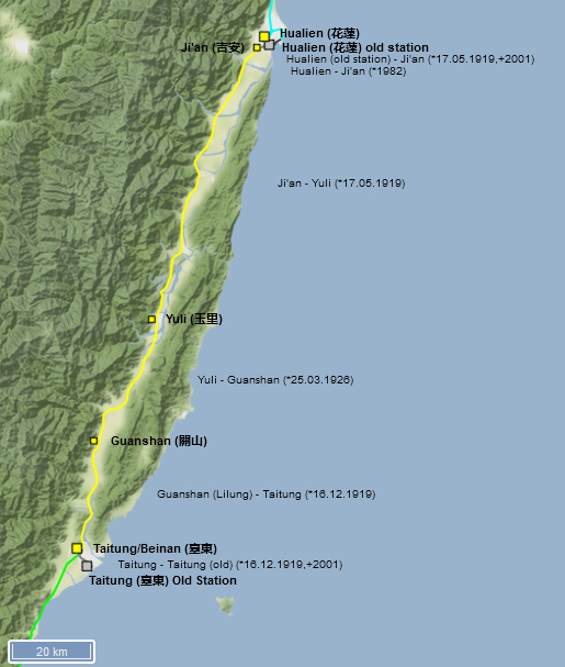 Figure 22: Map of the East Coast/Taitung Line marked in yellow with opening dates. The North Link Line is marked in turquoise, the South Link Line in green. Closed branch lines are marked in grey (Terrain by Stamen.com)
 Figure 23: Detailed view of the railway network in the Taitung area. The start / end point of the East Coast/Taitung Line, which was isolated until 1980, was in the city center of Taitung. The Taitung Line (marked in yellow) towards Gushan was opened in 1919 in 762mm gauge (1926 extended to Hualien). After it was connected to the rest of the network in Hualien in 1980, the line was re-gauged to Cape Gauge until 1982. Due to the planned construction of the South Link Line, the train station was relocated from the city center to the north-western outskirts (former Beinan Station), and the downtown branch was closed in 2001. The first part of the South Link Line (marked in green) starting from the new Taitung station to Zhiben since 1985, the remaining section to Fangliao was opened in 1991 and thus finally closing the ring line around the island (Terrain by Stamen.com)
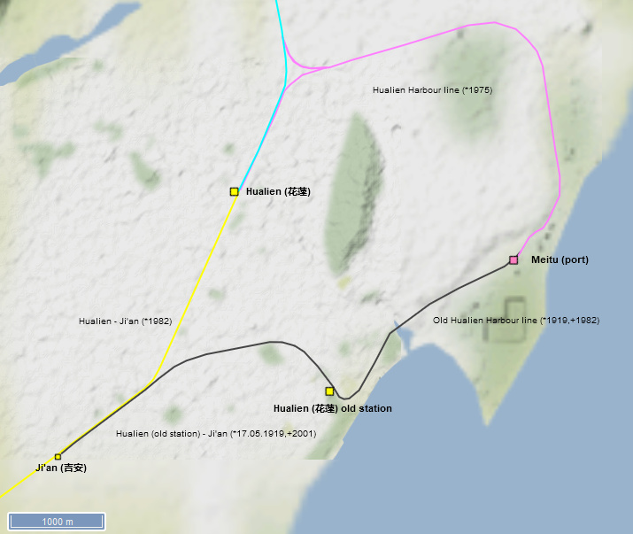 Figure 24: Detailed view of the railway network in the Hualien area. The start / end point of the Taitung Line (marked in yellow), which was isolated until 1980, was, as in Taitung, in the city center of Hualien, from where there was an extension of the route to the port (freight traffic only). As early as 1975 a new railway connection to the port was laid out in Hualien (marked in pink) for the construction of the North Link Line (marked in turquoise), which was connected to the newly built North Link Line with a track triangle in both directions. With the opening of the North Link Line in 1980, the previously isolated East Coast/Taitung Line was connected to the rest of the railway network. As part of this, the Hualien train station was relocated to the north-western outskirts of the city and the section to the old station in downtown Hualien became a branch, which was later closed (Terrain by Stamen.com)
| From | To | Length (km) | Opening Year | Remark |
| Taitung (臺東) old station | Guanshan (關山) | 36.5 | 16.12.1919 | built in 762mm gauge initially by Taitung Development Company; taken over by Government Railways shortly after opening; re-gauged to 1,067mm until 1982; branch from Beinan to Taitung old station/downtown closed on 1, October 2001 |
| Guanshan (關山) | Yuli (玉里) | 37.8 | 25.03.1926 | built in 762mm gauge; re-gauged to 1,067mm until 1982 |
| Yuli (玉里) | Hualien (花蓮) old station | 83.6 | 17.05.1919 | built in 762mm gauge; re-gauged to 1,067mm until 1982; branch from Jinan to Hualien old station/downtown and Hualien port closed somewhen after re-gauging |
| 150.9 | initially 171.8km; reduced due to re-alignments and closure of branches to Hualien and Taitung downtown |
 Figure 25: Historic view of Hualien port with goods cars on a siding. At this point of time, the Taitung/East Coast Line stuill had a gauge of 762mm (花蓮縣文化局, CC BY-SA 4.0
  Figure 26: This photograph dated from 1962 shows a brand new diesel rail car of type LDR2300 at Hualien station (Unknown author, Public domain, via Wikimedia Commons)
 Figure 27: This photo dated from 1982 shows the re-gauging works from 762mm to 1,067mm along the Taitung/East Coast Line (National Development Council, Attribution, via Wikimedia Commons)
 Figure 28: This is how modern day traffic looks on the Taitung/East Coast Line after re-gauging and electrification. The remaining single track sections along the line should become double-tracked by 2027 (Cassiopeia sweet, Public domain, via Wikimedia Commons)
Alongside the east coast between Su‘ao and Hualien, the up to 4,000m high mountain ranges extend directly to the rugged shore line with high cliffs. There is hardly any permanent settlement in this area. Thus, the East Coast/Taitung Line between Hualien and Taitung remained isolated from the rest of the country for a long time. The region could not be reached by rail or road. Those who wanted to go to Hualien or Taitung from the west coast had to take the train to Su’ao and change to the ferry there. In 1973, Typhoon Nora caused such severe damage to the east coast that it could only be reached by air or sea for several weeks. Since the construction of a road was considered too expensive, it was decided to build a 79.2 km long railway line from Su’ao to Hualien. Construction began in the same year; the difficult geography required the construction of 91 tunnels and 16 large bridges, so that the line could not go into operation until February 1st, 1980. To support the construction works, a new branch line to the port at Hualien was created at the same time. In Su'ao, the North Link Line does not start at the Su'ao terminus of the Yilan Line, but at Su'aoxin station shortly before Su'ao. The section from Su'aoxin to Su'ao remained in operation as a branch line. At Hualien, the North Link Line also did not connect at the terminus of the East Coast/Taitung Line, but at a new station northwest of the city centre. The branch to the old terminus was closed after the East Coast/Taitung Line was re-gauged to cape gauge until 1982/85.
The number of passengers on the line rose rapidly and the line's capacity was soon exhausted. In 1992, electrification and the double-track expansion of the line began. However, the work took time due to the geographical difficulties, as, among other things, a new tunnel more than 10 km long had to be bored. In 2003, the line was finally electrified throughout, and until 2005, the line was then also consistently double-tracked. On April 2nd 2021, one of the worst railway accidents on Taiwan happened on the North Link Line just north of Hualien when an express train crashed into a construction vehicle that had just fallen onto the line just before a tunnel. 49 people were killed in the accident.
 Figure 29: Map of the North Link Line marked in turquoise with opening dates. The connecting Yilan in the north is marked in red, the connecting East Coast/Taitung Line in the south is marked in yellow (Terrain by Stamen.com)
 Figure 30: Detailed view of the route network in Su‘ao. To build the Yilan Line (marked in red), a port was built in Su’ao, the first section was opened in 1919, and since 1924 the Yilan Line has been completed continuously to Badu (and on via the Western Line to Taipei). With the construction of the North Link Line (marked turquoise), the Su’ao train station was relocated to the north-western outskirts of the city, as in Hualien and Taitung (new Su’aoxin train station). In contrast to Hualien and Taitung, the section in the city center was not closed. Some passenger trains on the Yilan Line continue to start / end in the old Su’ao station, the extension to the port is only used very sporadically for freight traffic (Terrain by Stamen.com)
Figure 31: Detailed view of the railway network in the Hualien area. The start / end point of the Taitung Line (marked in yellow), which was isolated until 1980, was, as in Taitung, in the city center of Hualien, from where there was an extension of the route to the port (freight traffic only). As early as 1975 a new railway connection to the port was laid out in Hualien (marked in pink) for the construction of the North Link Line (marked in turquoise), which was connected to the newly built North Link Line with a track triangle in both directions. With the opening of the North Link Line in 1980, the previously isolated East Coast/Taitung Line was connected to the rest of the railway network. As part of this, the Hualien train station was relocated to the north-western outskirts of the city and the section to the old station in downtown Hualien became a branch, which was later closed (Terrain by Stamen.com)
Figure 30: Detailed view of the route network in Su‘ao. To build the Yilan Line (marked in red), a port was built in Su’ao, the first section was opened in 1919, and since 1924 the Yilan Line has been completed continuously to Badu (and on via the Western Line to Taipei). With the construction of the North Link Line (marked turquoise), the Su’ao train station was relocated to the north-western outskirts of the city, as in Hualien and Taitung (new Su’aoxin train station). In contrast to Hualien and Taitung, the section in the city center was not closed. Some passenger trains on the Yilan Line continue to start / end in the old Su’ao station, the extension to the port is only used very sporadically for freight traffic (Terrain by Stamen.com)
Figure 31: Detailed view of the railway network in the Hualien area. The start / end point of the Taitung Line (marked in yellow), which was isolated until 1980, was, as in Taitung, in the city center of Hualien, from where there was an extension of the route to the port (freight traffic only). As early as 1975 a new railway connection to the port was laid out in Hualien (marked in pink) for the construction of the North Link Line (marked in turquoise), which was connected to the newly built North Link Line with a track triangle in both directions. With the opening of the North Link Line in 1980, the previously isolated East Coast/Taitung Line was connected to the rest of the railway network. As part of this, the Hualien train station was relocated to the north-western outskirts of the city and the section to the old station in downtown Hualien became a branch, which was later closed (Terrain by Stamen.com)
| From | To | Length (km) | Opening Year | Remark |
| Su'aoxin (蘇澳新) | Hualien (花蓮) | 79.2 | 1980 | opened for public transport on 01.02.1980 |
| 79.2 |
 Figure 32: This photo shows the North Link Line just north of Hualien. On the right hand side, the two tunnel portals of the line can be seen. The terrible train accident April 2nd 2021 happened at the left tunnel portal (Fred Hsu, CC BY-SA 3.0
 .jpg) Figure 33: Goods trains on the North Link Line mainly transport cement which is produced along the East Coast and the transported to the urban areas on the West Coast (billy1125 from Hualien, Taiwan, CC BY 2.0
Figure 33: Goods trains on the North Link Line mainly transport cement which is produced along the East Coast and the transported to the urban areas on the West Coast (billy1125 from Hualien, Taiwan, CC BY 2.0  Figure 34: A TEMU1000 type train on the North Link Line (Cassiopeia sweet, Public domain, via Wikimedia Commons)
The southern tip of Taiwan is very mountainous and prone to constant natural events (storms, heavy rain, landslides). There are hardly any permanent settlements apart from a few coastal towns. During the Japanese occupation era, there were plans to connect the southern tip of the island with a railway line, but the plans were not implemented. After the war, there were several attempts to build the line (1947, 1958, 1963, 1968), but these were repeatedly rejected by the government. After the North Link Line connected the isolated East Coast/Taitung Line to the rest of the railway network in 1980, only a southern link was missing to close the railway ring around the island. Finally, the government decided in 1980 to build the 98.2 km long South Link Line. Instead of a route around the southern tip, a variant was chosen that bends east from Fangshan, leads through the mountains, and then runs along the east coast to Taitung. In Taitung, the South Link Line was connected to the East Coast/Taitung Line at a station north of the city centre and not at the old terminus in the city centre. The old section of the East Coast/Taitung Line to the terminus remained a branch line until it was closed in 2001. The first sections south of Taitung, which lead through still flat coastal areas, opened in 1985 and 1988. The rest of the route is purely a linking route to close the railway ring around the island; there are no local traffic needs due to the lack of any permanent settlements along the route. The construction of the line required 35 tunnels and 158 bridges as it leads through mostly deserted mountain regions and over several rivers, which swell especially during the typhoon season. Damages like landslides caused by typhoons lead to regular closures of the line; in 2010, it had to be closed for a longer time. Since then, the TRA tries to make the route more “weatherproof” by realigning it. Due to the rather low traffic, the South Link Line is still largely single-tracked and was only electrified in 2020 as the last section of the ring line. A double-track expansion of the entire route is currently not planned. To connect the city of Hengchun on the southern tip of the island, a branch line from Neishi on the South Link Line is planned (see Planned Lines).
 Figure 35: Map of the South Link Line marked in green with opening dates. The connecting Pingtung Line in the west is marked in orange, the connecting East Coast/Taitung Line is marked in yellow (Terrain by Stamen.com)
Figure 36: Detailed view of the railway network in the Taitung area. The start / end point of the East Coast/Taitung Line, which was isolated until 1980, was in the city center of Taitung. The Taitung Line (marked in yellow) towards Gushan was opened in 1919 in 762mm gauge (1926 extended to Hualien). After it was connected to the rest of the network in Hualien in 1980, the line was re-gauged to Cape Gauge until 1982. Due to the planned construction of the South Link Line, the train station was relocated from the city center to the north-western outskirts (former Beinan Station), and the downtown branch was closed in 2001. The first part of the South Link Line (marked in green) starting from the new Taitung station to Zhiben since 1985, the remaining section to Fangliao was opened in 1991 and thus finally closing the ring line around the island (Terrain by Stamen.com)
Figure 35: Map of the South Link Line marked in green with opening dates. The connecting Pingtung Line in the west is marked in orange, the connecting East Coast/Taitung Line is marked in yellow (Terrain by Stamen.com)
Figure 36: Detailed view of the railway network in the Taitung area. The start / end point of the East Coast/Taitung Line, which was isolated until 1980, was in the city center of Taitung. The Taitung Line (marked in yellow) towards Gushan was opened in 1919 in 762mm gauge (1926 extended to Hualien). After it was connected to the rest of the network in Hualien in 1980, the line was re-gauged to Cape Gauge until 1982. Due to the planned construction of the South Link Line, the train station was relocated from the city center to the north-western outskirts (former Beinan Station), and the downtown branch was closed in 2001. The first part of the South Link Line (marked in green) starting from the new Taitung station to Zhiben since 1985, the remaining section to Fangliao was opened in 1991 and thus finally closing the ring line around the island (Terrain by Stamen.com)
| From | To | Length (km) | Opening Year | Remark |
| Taitung (臺東) new station | Zhiben (知本) | 11.6 | 1985 | opened for public transport on 15.07.1985 |
| Zhiben (知本) | Taimali (太麻里) | 11.7 | 1988 | opened for public transport on 01.01.1988 |
| Taimali (太麻里) | Fangliao (枋寮) | 74.9 | 1991 | opened for public transport on 16.12.1991 |
| 98.2 |
 Figure 37: A passenger train on the South Link line before it was electrified (The original uploader was Encino at Chinese Wikipedia. / CC BY-SA (http://creativecommons.org/licenses/by-sa/3.0/) in Wikimedia Commons)
 Figure 38: Trial runs with an electric rail car of type EMU900 on the South Link Line in 2020 just before the offical opening of the electrification on the South Link Line. The South Link Line is prone to natural hazards especially along the East Coats section which requires constant repairs and realignments (Taiwan Railways Administration, Attribution, via Wikimedia Commons)