Railway lines on Taiwan Island
This page lists all Government Railway and High-Speed lines on Taiwan Island ordered by main, branch and sidings lines as well as planned lines. Further details of the lines are availabe underneath the links in the sub menu listed above. The historic order of the opening of the main and branch lines can be found under menu item History. Further details on each line are described below. All Government Railway Lines except the East Coast Line were built in cape gauge (1,067mm).
| Line | From | To | Length (km) | Status | Remark | Map (click on map for large image) |
| Main Lines | ||||||
| Western/ Trunk Line | Keelung (基隆) | Kaohsiung (高雄) | 404.5 | in service, electrified (25kV/60Hz), mostly double tracked | The Western/Trunk Line connects the port at Keelung with Kaohsiung, the second largest city in Taiwan. Until the opening of the high-speed line, the Western/Trunk Line was by far the most important line as it connects all the agglomerations on the densely populated west coast where around 90% of all Taiwanese live. The first section between Keelung and Taipei was opened in 1891 being the first railway line on Taiwan Island. The complete line went into service in 1908. The section between Zhunan and Changhua was aligned inland through mountainous areas. This proved to be a bottleneck and thus a parallel section along the coastline was opened in 1922. The old section became the Mountain/Taichung Line (see below). Double tracking already started in 1912 between Keelung and Taipei. Except a few short sections along the coastline, the complete line is double tracked. The line was electrified in 1979 being the first line to be electrified on Taiwan Island. After the realignment of the Mountain/Taichung Line in 1998, the section between Zhunan and Changhua lost most of its traffic. |  |
| Mountain/ Taichung Line | Zhunan (竹南) | Changhua (彰化) | 85.5 (87.9 until 1998) | in service, electrified (25kV/60Hz), double tracked | The Mountain/Taichung Line was initially a section of the Western/Trunk Line, until a parallel section along the coastline was opened in 1922. The line cuts through mountainous areas, which required the construction of several tunnels and bridges. This made the line a bottleneck until the parallel section along the coastline was opened in 1922 (see above). In 1998, the line received a complete realignment with the construction of a long tunnel, which shortened the length of the line by 2.4km. The old alignment over the mountains was closed. Some sections of the old alignment see irregular tourist traffic with historic rolling stock. |  |
| Chengzhui Line | Chenggong (成功) | Zhuifen (追分) | 2.2 | in service, electrified (25kV/60Hz), double tracked | Alongside the opening of the parallel coastline section between Zhunan and Changhua (see above), a track triangle went into service north of Changhua to allow direct trains between the coast line section and Taichung. The line was double tracked and electrified a few years ago. |  |
| Yilan Line | Badu (八堵) | Su'ao (蘇澳) | 93.6 | in service, electrified (25kV/60Hz), double tracked | The Yilan Line prolongs the northern end of the Western/Trunk Line to the eastern coastline. It crosses through areas, which had rich coal resources. The opening happened in section wise from both directions between 1919 and 1924. Until the opening of the North Link Line in 1979/80, Su’ao was terminus of the line (in fact, it still is, as the North Link Line branches off at Su’aoxin). |  |
| North Link Line | Su'aoxin (蘇澳新) | Hualien (花蓮) | 79.2 | in service, electrified (25kV/60Hz), mostly double tracked | The missing link between the Yilan Line and the isolated East Coast/Taitung Line went into service only in 1979/80. The North Link Line between Su’aoxin and Hualien runs along a rugged coastline with high cliffs. Thus, construction of long tunnels and bridges were required. | 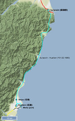 |
| East Coast/ Taitung Line | Hualien (花蓮) | Taitung (臺東) | 150.9 (171.8 until re-gauging) | in service, electrified (25kV/60Hz), mostly double tracked | The East Coast Line/Taitung Line connects the two largest cities on the east coast through a valley that runs in parallel to the coastline. The opening happened in section wise from both directions between 1919 and 1926. In contrast to all other Government Lines, the line was constructed in 762mm gauge due to the expected low transportation figures. The line remained completely isolated until the opening of the North Link Line in 1979/80 (see above). Afterwards, the re-gauging of the line to cape gauge (1,067mm) including several realignments started. It was largely finished in 1982; the last realignments went into service in 1985. The old termini of the line in Hualien and Taitung lay aside of the new alignment and lost their traffic later on. Those realignments shortened the initial length of the line from 171.8km to 150.9. Taitung remained terminus of the line until the first part of the prolongation towards Fangliao (part of the South Link Line) was opened in 1985 (see below). |  |
| South Link Line | Taitung (臺東) | Fangliao (枋寮) | 98.2 | in service, electrified (25kV/60Hz), partly double tracked | The South Link Line formed the last missing link in the ring line around the island. It was finally opened in 1991, exactly 100 years after the opening of the first section of the ring line (Keelung – Taipei). First sections on the eastern coastline already opened 1985 and 1988. The line runs mostly through sparsely populated mountainous jungle area. | 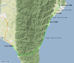 |
| Pingtung Line | Kaohsiung (高雄) | Fangliao (枋寮) | 61.3 (64.4 until 2008) | in service, electrified (25kV/60Hz), mostly double tracked | The Pingtung Line prolongs the Western/Trunk Line to the southern tip of the island. Opening happened section wise between 1907 and 1941. The 11.2km long final section was dismantled in 1944 only three years after the initial opening. It was reopened in 1953. Until the opening of the South Link Line in 1991 (see above), Fangliao remained the terminus and was the southernmost station on Taiwan Island. |  |
| High-speed Lines | ||||||
| THSRC Line | Nangang (恆春) | Zuoying (左營) | 349.5 | in service, electrified (25kV/60Hz), double tracked | The 349.5km long high-speed track was opened in 2007. Around 73% of the line runs on bridges (252km) and 18% in tunnels (63km), the minimal radius is 6.5km, the maximum grade is around 3.5%. There are 12 stations along the line, but only few trains stop at all stations. The maximum allowed speed is 350km/h (except in the tunnel section underneath Taipei with a maximum speed of 130km/h). However, trains run only with a maximum speed of 300km/h. |  |
| Branch Lines | ||||||
| Tamsui Line | Taipei (台北) | Tamsui (淡水) | 21.2 | closed & dismantled | The Tamsui Line connected the harbour at Tamsui with the city of Taipei. Opened in 1901 with a short branch to Xinbeitou to connect the hot springs there in 1916, the line was closed in 1988. Large parts of the track bed were used for the construction of the Tamsui Line within Taipei’s metro network. |  |
| Xindian Line | Wanhua (萬華) | Xindian (新店) | 10.4 | closed & dismantled | The Xindian Line connected the coal mines south of Taipei with the Government Railway network. It was built and operated by the coal mines. Alongside the coal transport, passenger transport on the line became more and more important (commuter traffic during weekdays, excursions to the mountains on the weekends). The TRA took over the line after WW II and closed it 1965 after much of the traffic had switched to the parallel road. Today’s Xindian Line of Taipei’s metro system (MRT) follows the old Xindian Line, but mostly underground. |  |
| Pinxi Line | Sandiaoling (三貂嶺) | Jingtong (菁桐) | 12.9 | in service | The Pinxi Line initially connected the coal mines southeast of Taipei with the Government Railway network at Sandiaoling on the Yilan Line. Built and operated by a coal mining company, it was taken over by the government in 1929. With the closure of the last coal mines in the 1980s, the line lost most of its traffic. Thanks to the growing passenger traffic (mainly tourists) the line is still in service. |  |
| Jiji Line | Ershui (二水) | Checheng (車埕) | 29.7 | in service | The Jiji Line was initially built to support the construction of a large hydroelectric project in the mountains above Checheng. After construction was finished, the government took over the line. The line survived thanks to the growing tourist traffic on the line. Due to earthquake damages, the line was closed in 1999 and only reopened in 2001. |  |
| Donggang Line | Zhen'an (鎮安) | Donggang (東港) | 6.2 | closed (re-opening under discussion) | The Donggang Line was opened as a short branch line in 1940 alongside the extension of the Pingtung Line for military reasons. Parts of the line were closed in 1991. The remaining part of the line was still used by the army until 2002. There are plans for a reopening of the line. However, so far without any tangible results. | 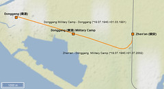 |
| Neiwan Line | Hsinchu (新竹) | Neiwan (內灣) | 27.9 | in service, partly double tracked and electrified (25kV/60Hz) | Construction of the Neiwan Line already started in WW II for transportation of minerals and coal, but the works were stopped at the end of the war. The line finally opened in 1951 as the first new line of the TRA. As part of the construction of the Liujia Line (connection of the high-speed railway station near Hsinchu to Hsinchu Station, see below), the first section of the Neiwan Line to Zhuzhong was double tracked and electrified in 2011. The remaining section is still in service thanks to tourist traffic. |  |
| Shenggang Line | Tanzi (潭子) | Oil depot | 13.4 | closed & dismantled | The Shenggang Line connected an army camp and oil depot near Taichung to the Government Railway network. The line opened in 1957 and closed in 1999. Meanwhile, a bikeway was built on large parts of the track bed. |  |
| Dongshi Line | Fengyuan (豐原) | Dongshi (東勢) | 14.7 | in service | The Dongshi Line runs into a valley northeast of Taichung. It was built in 1959 to serve the forest industry and to support the construction of the first road crossing the mountain range to the east coast. Later, mainly commuters and students used the line. However, around 30 years after its opening, the line was closed in 1991 and transferred into a bikeway. |  |
| Shen'ao Line | Ruifang (瑞芳) | Badouzi (八斗子) (initially to Liandong (簾洞)) | 4.6 (initially 12.7) | partly in service, partly closed & dismantled | The Shen’ao Line was built in 1965 to connect a coal power plant at Shen’ao with the Government Railway network. It partly reused a mine railway in 762mm gauge, which connected a gold mine near Liandong with the port in Keelung. In 1967, the Government Line was extended to Liandong. Less than ten years later, large parts of the extension were already closed to give space for a coastal road. Passenger traffic ceased in 1989 and only the tracks to the coal power plant remained. The power plant itself closed in 2007, leading to the immediate closure of the remaining section. Thanks to the opening of a large Sealife Museum at Badouzi, the section to Badouzi was reopened in 2014. |  |
| Linkou Line | Taoyuan (桃園) | Linkou (林口) | 18.4 | closed & dismantled | The Linkou Line connected another coal power plant at the coast line near Linkou with the Government Railway network in Taoyuan. Passenger services started in 2005. When the Taoyuan station was put underground in 2012, the branch line lost its connection to the Western/Trunk Line and was immediately closed. |  |
| Shalun Line | Zhongzhou (中洲) | Shalun (沙崙) | 5.3 | in service, electrified (25kV/60Hz), double tracked | As the high-speed station for Tainan in Shalun is far away from the centre of Tainan, the TRA opened a new short branch line from Zhongzhou on the Western/Trunk Line to Shalun in 2011 in order to connect the high-speed railway station directly with the centre of Tainan. |  |
| Liujia Line | Zhuzhong (竹中) | Liujia (六家) | 3.1 | in service, electrified (25kV/60Hz), double tracked | As the high-speed station for Hsinchu in Liujia is far away from the centre of Hsinchu, the TRA built a connecting link. The link used the lower section of the Neiwan Line (see above Neiwan Line) which was double tracked and electrified. The remaining short section was newly constructed and opened in 2011. |  |
| Sidings | ||||||
| Hualien Port Line | Hualien/ Beipu | Meitu | 7.4 | in service | In order to facilitate the construction of the North Link Line, the port at Hualien received a new connection in cape gauge in 1975. It was used for the transportation of material for the construction of the North Link Line and the re-gauging and realignment of the East Coast/Taitung Line. The line still exists today, but is only used rarely. |  |
| Taichung Port Line | Taichung Port Station | Taichung Port | 7.8 | in service | To meet the growing exports, the government built a new modern port near Taichung. In 1976, it was connected with the coast section of the Western/Trunk Line. Currently, only sporadic goods trains that transport corn and wheat use the branch line. | 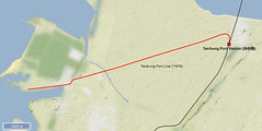 |
| Kaohisung Port Line (First Linggang) | Kaohsiung Port | Kaohsiung | 13.6 | closed & dismantled | The Kaohsiung port line connects the old terminus of the Western/Trunk Line at the old harbour of Kaohsiung with the new station in Kaohsiung (opened in 1941) by surrounding the city on the southern and eastern side. Close to the new station, the line also connected the large Qianzhen Depot with the Pingtung und Western/Trunk Line. The port line was finally closed in 2018; some sections were already closed earlier to give space for the new circle line tram. Once finished, the circle line tram should run on the complete track bed of the former port line. | 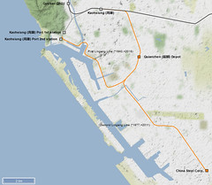 |
| Kaohisung Port Line (Second Linggang) | Qianzhen Depot | China Steel Corp. | 8.6 | closed & dismantled | The port of Kaohsiung and attached industries expanded to the southeast in the 1970s. In 1977, they were connected to the existing port line. The branch line was closed in 2011. | |
| Keelung Harbour Line | Keelung | Keelung Harbour | 5.2 | closed & dismantled | The first piers at Keelung harbour were already connected to the first railway line from Keelung to Taipei in 1891. The line expanded together with the port during the upcoming decades. Especially locomotives and railcars exported from other countries arrived here and were directly unloaded onto the port line. With the partial lowering of Keelung station, the branch line lost its connection with the railway network and was thus closed. Eventually, a new tramline might be built on the still existing rails. |  |
| Songshan Airport Line | Songshan | Songshan Airport | 1.5 | closed & dismantled | In 1936, the Japanese Army opened the airport of Songshan close to Taipei and connected it via rail to the Western/Trunk Line. The connection was closed in 1976. | 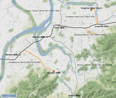 |
| Pingtung Airport Line | Pingtung | Pingtung Airport | 3.7 | closed & dismantled | The airport near Pingtung opened in the 1920s with a connection to the Pingtung Line at Pingtung station. The army used the connection until 1997. |  |
| Hsinchu Airport Line | Hsinchu | Hsinchu Airport | 4.3 | closed & dismantled | In 1937, the airport at Hsinchu was connected to the Western/Trunk Line at Hsinchu station. The army used the line until it was closed in 1997. | 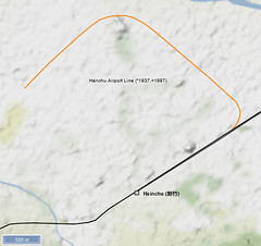 |
| Toufen Industrial branch line | Zhunan | Toufen Industrial zone | 3.3 | closed & dismantled | The government opened a large industrial area in Toufen near Zhunan after the war. Several factories had a railway connection to Zhunan station on the Western/Trunk Line. The industrial area still exists, the railways connection was closed in 2002. |  |
| Asia Branch | Tamsui | British Merchant Warehouse | 0.3 | closed & dismantled | When the Tamsui Line (see above under branch lines) was opened in 1901, several warehouses at Tamsui harbour were connected to the terminus via a short branch line. It was closed 1971. | no map available :-( |
| Sanzhangli Branch Line | Huashan | Army Arsenal | 2.0 | closed & dismantled | The Japanese Army connected its arsenal in Taipei with the Western/Trunk Line in the 1930s. After the war, it was taken over by the Kuomintang. The arsenal and railway line were closed in 1986. | |
| Zhonghe Line | Banqiao | Zhonghe | 6.2 | closed & dismantled | This line south of Taipei city centre replaced the Xindian Line (see above under branch lines) for transport of coal from the coal mines south of Taipei. In the late 1960s, it was planned to extend this line to a bypass around Taipei station for goods train. The plans were never realized and the line closed in 1990. The Zhonghe Line of Taipei’s metro MRT partly runs on the former track bed | |
| Chiayi Petrochina Branch | Chiayi/ Shuishang | Petrochina | 7.2 | closed & dismantled | The Japanese built a refinery south of Chiayi in the 1930s. It was connected to the Western/Trunk Line. The refinery is still in operation. However, since 2003 it is not connected to the railway network anymore. |  |
| Chiayi Airport Line | Chiayi/ Shuishang | Chiayi Airport | ? | closed & dismantled | The airport south of Chiayi had a connection to the Western/Trunk Line built during the Japanese occupation. It is now closed. Further details are unknown to me. | |
| Hengchun Airport Line | ? | Hengchun Airport | ? | closed & dismantled | The airport at Hengchun on the southern tip of Taiwan Island had a railway connection. As it was not close to any other railway line, the line most probably just ran to the harbour at Hengchun. Further details are unknown to me. | no map available :-( |
| Tobacco Factory | ? | ? | ? | closed & dismantled | no details found so far :-( | no map available :-( |
| Relief Agency | ? | ? | ? | closed & dismantled | no details found so far :-( | no map available :-( |
| Datong Yunli Xingyun | ? | ? | ? | closed & dismantled | no details found so far :-( | no map available :-( |
| Planned Lines | ||||||
| Zhongheng Line | Taichung (台中) | Hualien (花蓮) | 121.77 | planned, but never realized | In 1896, a Japanese survey team had already searched for a diameter line that would cross the island from west to east. However, the obstacles formed by mountain ranges with heights of 3,000m and more were too big. Nearly 30 years later, a second plan for a diameter line was drafted in 1923. The realization was first postponed and finally the plans were dropped due to the start of WW II. The TRA made a third attempt after the war for a 122km long line from Taichung to Hualien. As more than 50% of the line would have been in tunnels, the costs were too high and the TRA decided to build the North Link Line to connect the isolated East Coast Line with the railway network. | 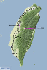 |
| Taichung Circle Line | Dajia (大甲) | Houli (后里) | 13.4 | first plans rejected | Railway lines to the east (Mountain/Taichung Line), south (Chengzhui Line) and the west (Coast section of Western/Trunk Line) surround the agglomeration of Taichung. A section between Dajia and Houli would be the missing link for a circle line around the agglomeration of Taichung. There has already been a sugar railway line between Dajia and Houli since 1 July 1912. However, the line was closed and the track bed is not available anymore. The construction of a new 13.4km long line would cost around 2 billion EUR. Thus, the government rejected the plans in 2019. |  |
| Tanaka Line | Tianzhong (田中) | Changhua THSRC (彰化) | 3.0 | planned, construction started? | The TRA made good experiences with the connection of high-speed station lying far outside the city centres (see Liujia and Shalu Line above). This now also planned for Changhua THSRC railway station, which should be connected with the TRA network at Tianzhong on TRA’s Western/Trunk Line. Construction seems to have started in 2019; the line should open in 2025. | 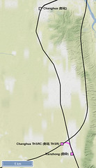 |
| Hengchun Line | Neishi (內獅) | Hengchun (恆春) | 37.72 | planned, construction started? | The city of Hengchun on the southern tip of the island is a popular tourist destination. First plans to build a railway line from Kaohsiung to Hengchun already occurred in 1876. However, only the Japanese started to build the railway line. By the end of WW II, the line had only reached Fangliao, which remained a terminus for a long time. Feasibility studies for the construction of the South Link Line foresaw an alignment via Hengchun as one opportunity. Due to the high cost, an alignment further north was built. Growing tourism with endless traffic jams and the isolation of Hengchun after a typhoon in 2005 gave the local politics arguments to construct a railway line. The Government finally agreed to the construction of a branch line from Neishi to Hengchun. Construction works started in 2019; by 2026 direct trains from Zuoying to Hengchun should allow travel times between Taipei and Hengchun in less than four hours. |  |
| Beiyi New Line | Nangang (恆春) | Toucheng (頭城)/ Yilan (宜蘭) | 36.3 - 56.4. | planned | The Yilan Line that connects the agglomeration of Taipei with the east coast takes a curvy detour around the northern tip of the island. In order to increase capacity of the line, reduce travelling time and provide alternatives to the congested roads, the government started plans for a direct line between Taipei and Yilan. Both plans for a TRA line built in cape gauge as well as a high-speed line (extension of the existing high-speed line) are under discussion. Initially, the cape gauge line was the favourite, now there is a tendency towards the high-speed line. As most of the variants cut underneath a water reservoir essential for the water supply of Taipei, the plans raise a lot of concern. A realization of the plans is still far away. |  |